Agaléga
Mauritian dependency of two islands in the Indian Ocean.

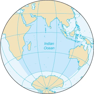
Agaléga is a dependency of Mauritius, consisting of two outer islands in the Indian Ocean about 1,050 km north of Mauritius Island. The islands are administered directly by the Prime Minister of Mauritius through the Prime Minister's Office to the Outer Island Development Corporation (OIDC). Known for coconut production and the Agalega day gecko, the population rose from 289 in 2011 to 292 in 2022.
- population_2022
- 292
- capital
- Vingt-Cinq (on South Island)
- highest_point
- Montagne d'Emmerez (hill on North Island)
Lore & Background
The islands may have been known to Arab and Malay sailors, but no written records confirm this. The first recorded settlement was founded by M. de Rosemond in August 1808, who discovered the bodies of two castaways and a bottle containing notes from privateer Robert Dufour. The hill Montagne d'Emmerez is named after a different individual or family, not a shipwrecked sailor named Adelaide d'Emmerez. Economic development began with Auguste Le Duc in 1827, who organized coconut oil and copra production. Historical monuments from 1827–1846 built by slaves include the village Vingt-Cinq (named after 25 lashes given to rebellious slaves), Slave Dungeons, an Oil Mill, and separate cemeteries for Blacks and Whites. A bridge between the islands was begun but swept away by severe weather. Father Victor Malaval brought the Catholic Church in 1897, building an improvised chapel on South Island. The population's origins reflect Mauritius becoming a British colony in 1810, abolition of the slave trade, abolition of slavery in 1835, and arrival of Asian laborers. Slaves were of Malagasy origin or from Madras, India, or freed from slave ships and Comoros ports. Folklore includes legends 'Calèche Blanc' and 'Princesse Malgache,' and the coded language 'Madam langaz Seret'—a mixture of French and Mauritian Creole where syllables are doubled with consonants replaced by 'g.'
Reader's Guide
Agaléga's significance lies in its status as a remote Mauritian dependency with a unique history shaped by slavery, colonial administration, and coconut-based economy. The islands' etymology is disputed, with three hypotheses: naming after Portuguese explorer Dom Pedro Mascarenhas's sailboat 'Galega'; after Galician explorer João da Nova (known as João Galego); or after Portuguese mariner Diogo Lopes de Sequeira's name 'Baixas da Gale.' Historical maps show the name evolving from Gale (1519) to Galega (1595) to Agalega (1587). The islands were examined by Captain Briggs of HMS Clorinde in 1811. In the 1960s, the UK and US discussed separating Agalega from British Mauritius like the Chagos Archipelago, but rejected it due to cost, political sensitivity, and poor anchorage. A 2015 memorandum of understanding on India–Mauritius military cooperation envisaged developing Agalega for an Indian military base, opposed by residents fearing threats to employment, self-determination, Creole language, and Mauritian sovereignty. On 11 December 2024, Cyclone Chido destroyed most homes and left the islands without power. The islands' legacy includes the coded slave language 'Madam langaz Seret' and monuments from the slave era.
Did You Know?
- The name Agaléga may derive from the Portuguese word 'Galega,' meaning 'from Galicia,' referring to explorer João da Nova.
- The village Vingt-Cinq is named after the 25 lashes given to rebellious slaves during the 1827–1846 period.
- A 2015 memorandum of understanding between India and Mauritius envisaged developing Agaléga for an Indian military base.
- A severe cyclone made landfall near North Island on 11 December 2024, destroying most homes and leaving Agaléga without power.
Geography, Governance & the Rhythm of Island Life
Agaléga comprises two small outer islands sitting roughly 1,050 kilometres north of Mauritius in the open Indian Ocean. Together they cover about 2,600 hectares. The larger, narrower North Island stretches 12.5 kilometres in length but only 1.5 in width, while the South Island is shorter at 7 kilometres yet broader at 4.5. The North Island holds both the community's airstrip and the settlement of Vingt-Cinq, which serves as the de facto capital. Administratively, the islands sit outside the usual provincial structure of Mauritius; they are overseen directly by the Prime Minister's Office through the Outer Island Development Corporation, a model shared with other remote dependencies such as St. Brandon. The resident population, numbering 289 at the 2011 census and rising to 330 by 2022, lives under the local name Agaléens. Coconut cultivation remains the backbone of the local economy, and the islands are also recognised internationally for the Agalega day gecko, a species found nowhere else on Earth.
The Name and the Long Trail of Discovery
The origin of the name Agaléga has generated at least three competing theories. The earliest, dating to 1501, links the islands to the Galician navigator João da Nova, whom his crew called João Galego; the feminine form "a galega" would naturally translate as "the Galician island." A second hypothesis credits the Portuguese explorer Dom Pedro Mascarenhas in 1512, who allegedly named the islands after his two vessels, the Galega and the Santa Maria. A third, less widely accepted account traces the name to Diogo Lopes de Sequeira in 1509, who supposedly called them Baixas da Gale after the gale-force winds shaping their shores. Early cartography confirms the name's fluidity: maps from 1519 through 1665 record variants such as Gale, Galera, Galega, and Da Galega before the modern form settled. In 1811, Captain Briggs of HMS Clorinde finally fixed the islands' position with precision, noting the heavy surf and surrounding reef that made landing treacherous.
Slavery, Industry & the Monuments That Remain
The islands' economic and political infrastructure took shape only after Auguste Le Duc arrived in 1827 as a French administrator dispatched by M. Barbé to organise coconut-oil and copra production. The period between 1827 and 1846 left a dense cluster of structures built by enslaved workers: the village of Vingt-Cinq, whose name memorialises the twenty-five lashes inflicted on rebellious slaves; the Slave Dungeons; an Oil Mill; separate cemeteries for Black and White residents; and an unfinished bridge linking the two islands, which was destroyed by severe weather. The enslaved population itself was drawn from Malagasy communities, Madras in India, the Comoros slave-trading ports, and in some cases freed directly from slave ships. The broader political context shaped everything: Mauritius passed to British control in 1810, the slave trade was abolished, and full emancipation followed in 1835, after which unskilled Asian labourers began arriving. These layered histories remain embedded in the physical landscape and in the community's collective memory.
Folklore, a Secret Tongue & the Arrival of Faith
Agaléga's cultural life carries traces of its layered past in ways both tangible and mysterious. The islands' folklore includes legends such as "Calèche Blanc" and "Princesse Malgache," stories passed down through generations. Perhaps most remarkable is the coded language known as "Madam langaz Seret," a hybrid of French and Mauritian Creole in which every syllable is doubled and the initial consonant of each word is replaced by a "g" — so "Français" transforms into "frangrançaisgais." This tongue emerged during the era of slavery, yet its precise origin, purpose, and the reasons for its particular phonological rules remain unexplained to this day. In 1897, Father Victor Malaval became the islands' first Catholic missionary, establishing an improvised chapel on the South Island and anchoring a religious community that persists to the present. Together, these cultural threads — the whispered coded speech, the ghost stories, the small chapel — give roughly three hundred Agaléens a shared identity distinct from the main island of Mauritius.
Frequently Asked Questions
What is Agaléga?
Agaléga is a Mauritian dependency made up of two small outer islands in the Indian Ocean. It functions as a remote territory under the direct oversight of Mauritius's central government.
Where exactly is Agaléga located?
The two islands sit roughly 1,050 kilometers north of Mauritius Island in the Indian Ocean, making them among the most isolated settlements in the broader Mauritian archipelago.
How is Agaléga governed?
Rather than being run by a local council, the islands fall under the direct authority of the Prime Minister of Mauritius through the Prime Minister's Office to the Outer Island Development Corporation. This gives Agaléga a governance structure quite distinct from other parts of Mauritius.
What is Agaléga known for?
The islands are recognized for their coconut cultivation and for being home to the Agalega day gecko, a species found nowhere else on Earth. The territory's highest point is Montagne d'Emmerez, a hill on the North Island.
How many people live in Agaléga?
As of 2022, the population stood at 292 residents, a slight uptick from the 289 recorded in the 2011 census. The administrative center is the settlement of Vingt-Cinq on the South Island.
More in Islands Of The Indian Ocean 1-24
Spotted an error? Know more?
This is a living reference — every entry is fact-audited, and reader corrections feed straight into our audit queue. Suggest an edit · See this site's audit record