British Indian Ocean Territory
A disputed territory created for a military base.

The British Indian Ocean Territory (BIOT) is a British Overseas Territory in the Indian Ocean, comprising the seven atolls of the Chagos Archipelago with over 1,000 islands. Its largest island, Diego Garcia, hosts a joint UK-US military facility. The territory was created in 1965 by separating the Chagos Archipelago from Mauritius, a move later deemed contrary to international law by the UN. The forced expulsion of the Chagossian people between 1968 and 1973, and ongoing disputes over sovereignty and the right of return, make the BIOT a significant subject in discussions of decolonization, human rights, and military geopolitics.
- Established
- 8 November 1965
- Total land area
- 60 square kilometres (23 square miles)
- Largest island
- Diego Garcia (27 square kilometres)
- Population (1968 estimate)
- 866 inhabitants
- Expelled population
- About 2,000 Chagossians
- Current legal residents
- Only UK and US military personnel and contractors
- Status
- British Overseas Territory; sovereignty disputed by Mauritius
Lore & Background
The Chagos Archipelago was known to Maldivian mariners and charted by Vasco da Gama in the early 16th century. France claimed the islands as a possession of Mauritius in the 18th century, settling them with African slaves and Indian contractors to work coconut plantations. After the UK captured Mauritius in 1810, the territory was ceded in the 1814 Treaty of Paris. Slavery was abolished in 1833, but laborers continued as indentured workers. By 1900, the population was 60% descended from African-Malagasy slaves and 40% from South Asian indentured laborers, speaking Chagossian creole. The plantations were bought by the Chagos-Agalega Company in 1962, covering 3,000 hectares.
Reader's Guide
The British Indian Ocean Territory's significance lies in its creation as a strategic military outpost and the subsequent human rights controversy. In 1965, the UK split the Chagos Archipelago from Mauritius to form the BIOT, enabling the construction of a joint US-UK military base on Diego Garcia. The entire Chagossian population, about 2,000 people, was forcibly expelled between 1968 and 1973 to Mauritius and Seychelles. Despite UN and International Court of Justice rulings supporting Mauritius's claim and the right of return, the UK has repeatedly denied Chagossians resettlement. A 2024 understanding to cede sovereignty to Mauritius while retaining the base was formalized in a 2025 treaty, but ratification was suspended in 2026 after US backlash. The territory remains a flashpoint for debates on decolonization, indigenous rights, and military necessity.
Did You Know?
- The Chagos Archipelago was known to Maldivian mariners as Fōlhavahi and Hollhavai.
- Diego Garcia once hosted a leper colony for patients from Mauritius, treated with turtle oil.
- The UK paid Mauritius £3 million for the territory's separation, plus £650,000 in 1972 for relocation costs.
- In March 2026, the BIOT Supreme Court ruled that Chagossians had the right to live on Île du Coin, but the territorial administration appealed.
Geographic Placement in the Western Indian Ocean
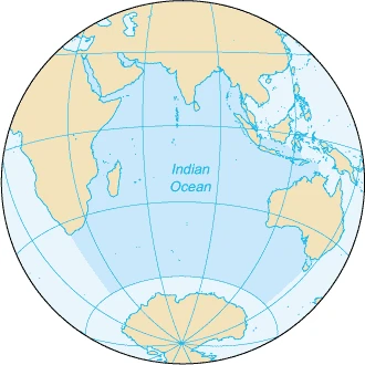
The British Indian Ocean Territory occupies a position within the western sector of the Indian Ocean's island geography. The ocean's scattered islands are broadly grouped into three zones—the eastern, western, and southern areas—and the Chagos Archipelago, which constitutes BIOT, falls squarely within that western grouping. It shares this zone with a remarkably diverse collection of landmasses, ranging from the vast land of Madagascar to the compact atolls of the Maldives, the volcanic territories of Réunion and Mayotte under French administration, and the multi-island archipelagos of Seychelles, including Mahé, Praslin, La Digue, and Silhouette. The western area also encompasses the Comoros, the Lakshadweep and Vypin islands of India, the Lamu and Mafia archipelagos of Kenya and Tanzania, and Socotra off Yemen. Within this crowded maritime neighborhood, the Chagos Archipelago stands as a distinct British-administered presence, its identity inseparable from the broader tapestry of western Indian Ocean island communities that stretch from the African coast to the island nations of the open ocean.
Composition: The Chagos Archipelago and Diego Garcia
The territory is identified in the Indian Ocean island record as the Chagos Archipelago, with Diego Garcia named explicitly as a component within that archipelago. This pairing—archipelago and its most prominent named island—defines the territory's geographic identity in the same way that the Zanzibar Archipelago is defined by Zanzibar itself, or the Mafia Archipelago by Mafia Island, or the Songosongo Archipelago by Songo Songo Island. The Chagos entry sits among a long catalogue of western Indian Ocean island groups, many of which are themselves collections of smaller islands: the Bazaruto Archipelago, the Quirimbas Archipelago, the Glorioso Islands, and the Scattered Islands of France, which include Banc du Geyser, Bassas da India, Europa Island, Juan de Nova Island, and Tromelin Island. The Chagos Archipelago, with Diego Garcia at its core, occupies its own line in this extensive inventory, a reminder that the Indian Ocean's western waters host an extraordinary density of named island entities, from single atolls to sprawling multi-island territories.
Sovereignty in Transition: From United Kingdom to Mauritius
What distinguishes the Chagos Archipelago from nearly every other entry in the western Indian Ocean island list is the notation attached to its name: the territory is described as belonging to the UK while simultaneously being in the process of transitioning to Mauritius. This dual designation sets it apart from the straightforward national attributions that accompany its neighbors—Madagascar listed simply as Madagascar, the Comoros as a sovereign entity, the Seychelles islands under their own name, and the French territories of Mayotte, Réunion, and the Scattered Islands clearly marked as French. Mauritius itself appears as a separate western Indian Ocean entry, accompanied by its own satellite islands of Agaléga, Cargados Carajos (St. Brandon), and Rodrigues. The Chagos entry thus captures a moment of geopolitical flux, a sovereignty handover in progress, where the island group is no longer unambiguously one nation's possession but is caught between two. In a list where most islands carry a single, settled national label, the Chagos Archipelago's parenthetical note of transition marks it as a unique and evolving entry in the Indian Ocean's island geography.
A Node in the Indian Ocean's Three-Zone Island Network
The Indian Ocean's islands, as catalogued in the reference material, are organized into three broad geographical areas: eastern, western, and southern. The eastern zone contains the largest concentration of entries, drawing from India (Andaman, Nicobar, Pamban, St. Mary's Islands), Australia (Ashmore and Cartier, Christmas, Cocos Keeling, Rottnest, and numerous others), Indonesia (Enggano, Mentawai, Nias, Simeulue, Sabang), Malaysia (Langkawi, Penang), Myanmar (Mergui Archipelago), Sri Lanka (Mannar Island), and Thailand (Phi Phi, Phuket). The southern zone is sparser, holding Heard Island and McDonald Islands for Australia, the French territories of Île Amsterdam, Île Saint-Paul, and the Kerguelen Islands, and South Africa's Prince Edward Islands including Marion Island. The Chagos Archipelago, with Diego Garcia, belongs to the western zone, which blends African coastal islands, island-nation atolls, and European overseas territories. BIOT's position within this three-part framework underscores how the Indian Ocean's island geography is not a single uniform system but a layered mosaic of sovereignty, scale, and regional character, with the Chagos occupying a specific and now contested niche in the western sector.
Frequently Asked Questions
What is the British Indian Ocean Territory?
It is a British Overseas Territory consisting of the seven atolls of the Chagos Archipelago, home to more than 1,000 islands spread across roughly 60 square kilometres of land. Its largest island, Diego Garcia, hosts a joint UK-US military installation.
Why was the British Indian Ocean Territory created?
Britain separated the Chagos Archipelago from Mauritius in November 1965 primarily to secure Diego Garcia for a US naval base. The UN later ruled that this carve-out violated international law, so the territory's very existence remains legally contested.
What happened to the Chagossian people?
Roughly 2,000 Chagossians were forcibly removed from their islands between 1968 and 1973 to clear the way for the military facility. Their right to return is still unresolved, and the expulsion is widely cited as a landmark decolonization and human-rights issue.
Who actually lives in the British Indian Ocean Territory today?
There are no permanent civilian residents; the only people on the islands are UK and US military personnel and their contractors who support the Diego Garcia base. The pre-expulsion population of around 866 (1968 estimate) was entirely displaced.
Is the British Indian Ocean Territory internationally recognized?
Britain administers it as an overseas territory, but Mauritius and the UN dispute that legitimacy, arguing the 1965 separation was unlawful. This keeps BIOT at the centre of ongoing debates over decolonization and sovereignty in the Indian Ocean.
More in Islands Of The Indian Ocean 1-24
Spotted an error? Know more?
This is a living reference — every entry is fact-audited, and reader corrections feed straight into our audit queue. Suggest an edit · See this site's audit record